|
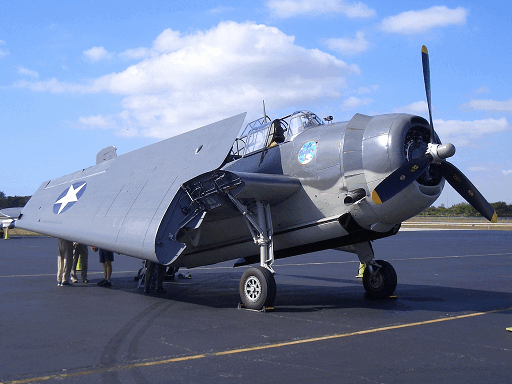
British film producer and director Simon Ludgate was filming a documentary on the Bermuda Triangle for National Geographic in 2004 (Named Science series), a principle part of which was to retrace Flight 19’s flight path (before they got lost, of course) in the Bahamas. For this flight he had secured an immaculately restored TBM Avenger similar to the planes of Flight 19.
Sparing no part of his budget he had asked the Danish Meteorological Office to analyze “their satellite data on electromagnetic anomalies around the earth” and made no secret of the fact to them that they were “investigating what scientific basis or otherwise there might be for the high incidence of disappearance s in one of the most patrolled, busy and tracked areas of sea in the world.” They began running their tests. Meanwhile: s in one of the most patrolled, busy and tracked areas of sea in the world.” They began running their tests. Meanwhile:
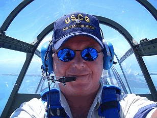
Simon Ludgate, during the flight.
“. . . We set off from Fort Lauderdale Airport in Florida in a beautifully-reconditioned Avenger bomber. Flown by a contemporary of the pilots who disappeared in the legendary Flight 19 Squadron, we took off at the same time 2:10 p.m. and set the same course to Chicken Island and Grand Bahama Island as Flight 19. I was being filmed by a chase plane and we had five cameras running on the Avenger. It was a beautiful day— better weather than Flight 19 had, and middle of the summer. We used old school compasses and a stopwatch to navigate with a modern GPS standing by. . . just in case.
“Almost immediately, I was struck by two things. The ocean and the sky are so similar in colour in that area that you could quite easily invert especially in a cloudless sky like that day and not realise it as the horizon had almost disappeared. There was hardly any difference in the sky and the sea. It was like flying inside a goldfish bowl. The second thing was how similar all the little formations of islands looked. We could have been anywhere in a 200 mile radius.
“We flew on for two hours and then something very odd happened. Our turn and slip indicators in both planes froze at exactly the same time. These are simple little devices like a carpenter’s spirit level which tell you whether or not you are skidding sideways in a turn. Even stranger, both our compasses started to behave weirdly. They were spinning and wavering as if magnetic north was moving round and round. I spoke to both pilots and suggested we fly on for a while, estimate our position then switch on the GPS and see if our satellite position was the same as our calculation.
“The next 20 minutes were really unsettling. You can see me checking the time on my dive watch at the moment the problem first starts. Then we played a dramatic reconstruction of what was heard by air traffic control from the leader of Flight 19 at the exact same moment— two hours into the flight as us. They reported their compasses looked wrong and the sky looked all funny. That was the last thing ever heard from them [sic]. I already knew this as my producer James Buchanan and I had been studying the transcripts as the basis for our reconstruction.
“Do you know— the next 20 minutes were very uncomfortable. What if the GPS didn’t work? What if we found ourselves 200 miles from our calculated position like another contributor to the programme had experienced in his Cessna between Grand Bahama and Fort Lauderdale? Twenty minutes passed and we fired up the GPS. We were 80 miles away from where the pilot thought we were. I think we experienced exactly the same anomaly as Flight 19. Despite the hot summer sun beating through the Plexiglass cockpit, I felt a chill run through me where I sat in the navigator’s seat behind the pilot.
“The sting in the tail was as we flew back towards Fort Lauderdale after a five hour flight— low on fuel— I looked up directly above me for some reason. We were at about five thousand feet and way, way up in the blue of the sky above me were five silver objects. I thought at first they were military jets practicing dog fights or an array of weather balloons. But these objects, which looked shiny and spherical, were darting around in big circles like the rings of the Olympic logo. They were so high I could only just make them out. And they were not leaving contrails like a jet. At that height they would almost certainly have been if they were jets. I estimated their speed, assuming my guess at their height was also roughly correct at 50,000 feet, was between 1,000 and 5,000 mph.
“When we landed we were all wrung out from the heat, stress and complexity of what just happened. And the Danish Meteorological Office satellite data analysis? They handed me a piece of paper when I got back to London with a printout of a map of the world. There was a blue triangular shape over the area stretching between Bermuda, Miami and Costa Rica as well as a similar shape over the South China Sea. The chief officer who gave me the printout said the blue area represented a drop of 6 % in the electromagnetic field in both areas. Not gravity. EMF. He couldn’t explain it but said that sort of anomaly was unprecedented. 0.6 % would be more what he’d expect. He went on to say that sort of inequality between two regions would act like two levels of water finding the same level. Which would store millions of amperes of electricity in the upper atmosphere. And as Nikola Tesla and latterly the much maligned John Hutchison in Vancouver discovered, Tesla coil type fields can change the molecular structure of metal and make it granular and brittle. It can also spin a compass like a Ferris Wheel. You can’t beat a bit of good science to bring a little clarity to a crazy story.”

The actual avenger in which Simon flew.
QUESTION: How big would you estimate the objects to have been?
SIMON: Hard to say as it was hard to judge the distance. I really couldn’t say accurately but maybe 20 feet wide apiece.
QUESTION: When did the compass begin to spin and when did it finally return to normal?
SIMON: After we passed over Grand Bahama and it returned to normal after we turned back over Grand Bahama so it was for about an hour.
|


