|
Grand Turk’s radio controller naturally wanted clarification:
GTR— The approximate shape, say again the approximate shape of the two large islands, please.
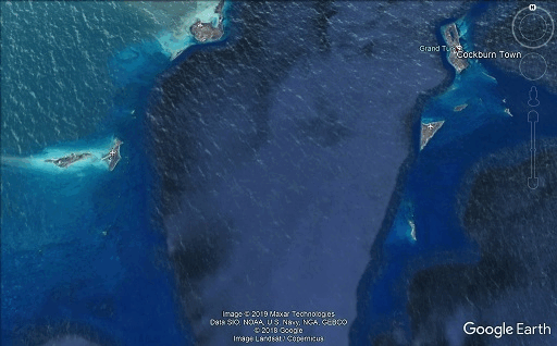
40L— One rather elongated and the other more round... or oval. . .or kinda diamond-shaped [signal begins to fade].
GTR— Zero Lima, Turk, stand by.
40L—. . .read you fiver, 40 Lima.
GTR— Four-Zero Lima, okay, you say your heading is 125 degrees and you see two large islands. Is that correct?
It was now 7:36 a.m.
40L— Grand Turk, this is 8040 Lima, I have passed two large islands. There is another island dead ahead of me at 120 degrees. [all italics mine]
GTR— Roger, stand by one moment, please.
40L— Grand Turk, I passed the two islands that I spoke of, and there is an island straight ahead of me at 120 degrees [fade-out].
GTR— Four-Zero Lima, understand; do you see any villages or anything on the island?
She did not say she was at the island. It was straight ahead. Another aircraft 26 Delta was breaking in.
GTR— [This] is Grand Turk. You are barely readable and 40 Lima is almost out of my range, come on [unreadable transmission]. GTR— Two-Six Delta, I am just barely reading you, sir. Can you switch to 121.5?
40L— Four-Zero Lima. . .[fadeout]. . .30 minutes fuel. . .[very weak].
This was obviously serious. 26 Delta spoke to Grand Turk radio to make sure:
26D— Okay, did you read. . .30 minutes fuel. . .[fadeout]. . .three islands in a line?
The mistake was minor. Cascio had indicated she had passed the two very large islands and was now, while on a course of 120/5, seeing an island straight ahead. There was no indication of how long ago she had passed the two very large islands.
Grand Turk Radio was talking to 26 Delta, trying to get the pilot to switch to 121.5, but Cascio broke in and asked Grand Turk to repeat. At 7:43 p.m. Cascio is heard on 121.5.
GTR— Four-Zero Lima, do you copy? This is Grand Turk on 121.5.
40L—[very very weak] Four-Zero Lima, I did not read...[fadeout]. . . island. . .zero. . .
Grand Turk Tower now cuts in.
GTT— Four-Zero Lima, this is Grand Turk Tower, how do you read me?
40L— Four-Zero Lima, I read you well.
It is 7:53 p.m.
GTT— Roger, give a short count, please.
40L— One two three four five, do you read me?
GTT— Four-Zero Lima, you are loud and clear. Say your present heading and airspeed.
40L— Grand Turk, this is 40 Lima. If you were transmitting to me just now, I missed it.
GTT— Four-Zero Lima, say your heading and airspeed, over.
It is 7:54 p.m.
40L— Grand Turk, this is 40 Lima, do you read me?
GTT— Roger, 40 Lima, reading you loud and clear. Say your heading and airspeed.
Unknown— Four-Zero Lima, say your heading and airspeed.
40L— Grand Turk, I do not receive you well now, you are garbled [signal strong].
GTT— Aircraft transmitting, get her heading and airspeed, please.
Unknown— Nine-Four-Three, say your heading and airspeed, go ahead.
GTT— Four-Zero Lima, turn on your landing lights and say your heading and airspeed. Do you read? Go ahead.
40L— Would you please repeat one more time, 40 Lima?
GTT— Roger, 40 Lima, turn on your landing lights, say your present heading and airspeed, please.
40L— Four-Zero Lima, landing lights are on, my airspeed is 100 knots, altitude 650 feet, my present heading is 180 degrees.
This is significant. She was at a low altitude and was no longer heading straight to that island in front of her at 120 degrees. She was headed south on 180 degrees. She now thought she saw an airplane straight ahead in the form of its light. It was headed 120 degrees. Grand Turk Tower started calling all aircraft in the vicinity on that heading. But Cascio soon broke over and apologized.
40L— Grand Turk, this is 40 Lima. I made an error, it was not an aircraft, it was a star. . .I was looking too hard. Four-Zero Lima, I’m sorry.
The time was now 7:57 p.m.
40L— Grand Turk, this is 40 Lima. I will circle over this island till you can give me an approximate heading to Turk. I think I might be able to make whatever you tell me. At least I will try. I have survival equipment aboard and one male passenger. If you can tell me where I am; if you can locate me. . .
GTT— Four-Zero Lima, do you have any islands in sight?
Unknown— Four-Zero Lima, do you have any islands in sight?
GTT— Aircraft transmitting, Turk, say your call sign.
869— Eight-Six-Niner.
GTT— Eight-Six-Niner, say your position.
869— Eight-Six-Niner, we’re on Bravo 12.
GTT— Roger, can you pick her up on your bird dog?
869— We have negative VHF bird dog.
GTT— Roger, Turk.
The time was now 7:59 p.m.
40L— Grand Turk, 40 Lima, do you read me?
GTT— Hello, 40 Lima, reading you loud and clear. How me?
40L— There seem to be any way out of this situation? [the famous line]
GTT— Four-Zero Lima, do you have an island in sight, over?
40L— I have. . .
GTT— Do you have survival gear on board, over?
40L—. . . an island in sight. I am remaining over this circular one, because I do not know what else to do.
Cascio is over a circular (round) island reached apparently by having gone south briefly from where she saw the other island “dead ahead.” It seems it is in sight of that other island, as she says she is staying over the circular island. Below, she will state there are 2 islands.
GTT— Four-Zero Lima, how long have you been flying from Georgetown to the island you’re over now?
Now South Caicos Island intrudes, trying to reach Cascio.
SCI— Four-Zero Lima, do you read South Caicos?
40L— This is 40 Lima, ah. . .I didn’t receive you well that time, would you please repeat?
SCI— This is South Caicos. Now do you hear?
40L— I’m sorry, I read you garbled, please try once more.
GTT— South Caicos, maintain radio silence. Four-Zero Lima, understand that you are receiving me loud and clear. Is that correct?
40L— Yes, I am receiving you loud and clear. I sometimes have a little difficulty, but most of the time am receiving you loud and clear, yes.
Convinced this means Cascio is near Turk, the GTT controller remains the main person in contact with Cascio. This seals Cascio’s and Rosen’s fate.
GTT— Four-Zero Lima, do you see any lights on the island?
40L— The two islands [all italics mine] are totally deserted.
GTT— Four-Zero Lima, you’re very, very close to Grand Turk, you are very close at 650 feet. I’m going to turn the runway lights up to maximum. Look around and see if you see them coming up.
40L— Four-Zero Lima, there are a lot of clouds in the area. . .it is difficult to s. . .to see.
GTT— Four-Zero Lima, we have the runway lights turned up and you must be very, very close. Do you have it in sight?
It is now 8:03 p.m.
40L— No, I do not. Would you give me a heading to come in on. I don’t know where I am. I have remained circling over these two islands because I did not know where I was or where to go from here; however, I do know that I am fairly close to you. Do you have any idea where I am or what heading to take from here?
. . .GTT— Four-Zero Lima, Turk, continue circling the island that you have in sight and stand by. We can’t give you a heading till we know where you are.
40L— Four-Zero Lima.
8:06 p.m.
40L— Grand Turk, I really think I’m beginning to get into trouble. Do you have any idea where I’m at?
GTT— Four-Zero Lima, we do not have you fixed. Turn left 270, fly for three minutes. I’ll give you a call if I don’t have you in sight. We’ll turn you around and go back to the island you have in sight. Do you understand? [Tower operator equated left with west]
40L— I’m remaining over the island I have in sight; however we do have our Mae Wests, just in case.
GTT— Four-Zero Lima, pick up a heading of 270 for three minutes.
Cascio either did not hear the 270 (WEST) instruction or ignored it.
It is now 8:08 p.m.
40L— Grand Turk, this is 40 Lima, do you read?
GTT— Four-Zero Lima, Grand Turk, how do you hear me now?
40L— I cannot hear you, would you please repeat?
GTT— Any aircraft in Grand Turk area, advise 40 Lima to turn back to a heading of 090.
40L—. . .090, I’m on my way, thank you.
GTT— Roger, turn back to 090, you’re going away from us now.
It is necessary to stop here now. It is hard to say that Cascio went any amount of time 270 West. Her radio transmission, which had been so clear, may simply have been breaking up and she never heard the instruction to go west. However, she clearly heard 090 and immediately went that way.
40L— I am on a heading of 090, I have left the island. Please keep talking to me. . .I need it.
GTT— Four-Zero Lima, Turk’s reading you loud and clear. You’re coming back to Turk now, and keep flying the airplane. How much fuel do you have left?
For Grand Turk Tower, this patchy communication (interpreted as happening when she went west) and renewed clarity (after turning around) must have caused a drastic change in the tower controller’s estimate of where she had been. Initially, he seems to have believed that when she said she had passed two large islands, one elongated and one diamond shape, that she had, in fact, overflown Grand Turk (elongated) and Salt Cay (diamond shape). This was no doubt further reenforced in his mind by recalling that Cascio was not receiving South Caicos well. She was receiving Turk better, indicating she was closer to him. Going west, her transmission should have gotten clearer. But it hadn’t.
Now, however, that she was going east her transmission was getting louder. He now believed she had been in the vicinity of North Caicos to the northwest, an amazingly fatuous deduction. The radio exchange now confirms this.
The time is now 8:10 p.m.
40L—. . .090, I am at an altitude of 900 feet, cruising at 110 miles per hour, we’re at 2,200 rpm.
GTT— What color is the airplane?
40L— Is there a chance that I will make it to you?
The time is now 8:11 p.m.
GTT— Roger, 40 Lima, you’re coming toward Grand Turk, coming in loud and clear. Continue this heading. We do not have a fix on you and I can’t give you a good heading, but you’re coming back towards the island.
40L— But you do have a fix in me. Is that correct?
GTT— We estimate you to be near North Caicos, a runway at South Caicos and you should come up on that island in just a moment.
40L— Are there. . .Grand Turk, are there any lights on South Caicos, on or Caicos?
8:12 p.m.
GTT— Roger, 40 Lima, affirmative, there are lights on South Caicos. Now turn to a heading of 120.
40L— Roger, this is 40 Lima. I am now on a heading of 120 at an altitude of 1,200 feet, airspeed 100 knots.
GTT— Roger, 40 Lima, you’re doing real well. Continue looking for the island; the lights are lit up at Grand Turk, the runway is lit up. You should be able to see the island shortly. Continue flying the airplane and say the type aircraft, please.
40L—. . . make the island, but not South Caicos. Are there any highways on which I can land?
8:13 p.m.
GTT— Four-Zero Lima, negative, there are no large highways that you can land on on the island, but there are runways at South Caicos.
40L— Grand Turk, do you estimate that I will make it as far as South Caicos with my fuel?
GTT— Roger, 40 Lima, we estimate you can make South Caicos with your fuel. What type aircraft are you?
40L— Cessna 172.
GTT— Four-Zero Lima, Cessna 172, continue flying the airplane, and do you have your landing lights still on?
40L— Affirmative.
GTT— Four-Four-Four, Grand Turk Tower, do you read?
GTT— Four-Zero Lima, give a short count to Clipper 444 on 121.5
It is 8:15 p.m.
40L— Grand Turk, 40 Lima, one two three four five, do you receive me?
GTT— Four-Zero Lima, Turk reading you loud and clear. Break, break! Clipper 444, you reading Grand Turk?
40L— I’m sorry, I did not receive your last information, repeat.
GTT— Roger, 40 Lima, do you have the island in sight yet?
40L— Four-Zero Lima, I can see no lights and cloud formations make it difficult to tell. I’m sorry, I do not have it in sight.
GTT— Say your present altitude.
40L— My present altitude is 1,000 feet.
GTT— Four-Zero Lima, set your altimeter, 29.89.
40L— Grand Turk, were you transmitting to me just then? I did not receive, I heard niner eight nine, that’s all.
GTT— Four-Zero Lima, we have an aircraft, a Clipper 444, who is trying to give you a fix on 121.5.
8:17 p.m.
40L— This is 40 Lima. I understand that there is an aircraft that is trying to get a fix on me. Four-Zero Lima, do you receive me?
GTT— Four-Zero Lima, you’re transmitting on 126.2.
8:18 p.m.
40L— This is. . .this is 40 Lima. I do not receive you well and I am now out of fuel. . .I think. It’s on empty and I haven’t got much left. My heading is 120.
This was the end. Despite Grand Turk initially hearing Cascio just after she headed east, her communication did not become better. Eventually, she too had trouble hearing Grand Turk. South Caicos never intruded again to declare they heard her clearly, which they would have had she been over North Caicos and coming closer to them on the heading Grand Turk had given her.
All that is certain now is that she was down, ditching on a dusk ocean.
This was the last contact with N8040L. From June 7 through June 10, seven U.S. Coast Guard and three U.S. Navy aircraft searched a 22,000-square-mile area. All vessels operating in the Caicos and Bahamas area were requested to maintain a watch for the aircraft. To this date, no trace of the aircraft or its occupants have been found.
There is, in truth, no way to determine exactly where she was despite the Grand Turk controller’s unwarranted certainty. Actually, his assumptions and directions do not make sense. Initially, he was positive that N8040L was near Grand Turk because of the clarity of her radio communications at only 650 feet altitude. Later, he is sure that she is quite a distance away at North Caicos and is sure she can reach South Caicos. Yet South Caicos, to our knowledge, never picked her up clearly.
In order to try and understand if there is an element of true mystery in this last flight and Cascio’s calls from nowhere, we must look in detail at Cascio’s own statements.
First, at 7:35 p.m. she said she had already passed two “sections of land”— which does sound like she was looking off to the Caicos islands. They are large and only narrowly divided by channels. At her relatively low altitude this would look like sections of land. Therefore it could be the land breaks on Providenciales and North Caicos.
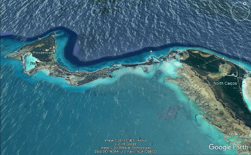
Passing over Providenciales on a course of 125, she would shortly overfly two relatively large islands— one of them Big Ambergris Cay.
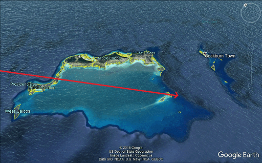
This is where it gets confusing. After passing these two islands, she saw an island dead ahead. From that island, maybe, she then went south to a nearby circular island. She remained by this circular island. The reader can consult the maps to figure where this might be in relation to the Ambergris cays.
The legend speculates that Carolyn Cascio was flying over two islands, usually one of them is promoted to be Grand Turk itself. Cascio then declared nothing was down there. This is a phenomenal statement considering Grand Turk is a vacation destination. In Alan Landsburg’s Secrets of the Bermuda Triangle (1978) host Peter Tompkins considers Cascio may have been plunged back in time long before Turk was inhabited. Yet hotel guests below could see her plane. They were glad, he said, when she flew off because the engine sound had been bothering them. Why couldn’t Cascio see anything down there? Locked at a time window, she finally flew off into space and time.
Richard Winer was probably the first to put wind in the sails of the legend. In The Devil’s Triangle (1974, he touches on the case and says that Cascio was circling an “island” offshore but couldn’t see the hotel or guests below. She then sped off into the night. He doesn’t mention any island or hotel by name.
In The Bermuda Triangle (1979) by Sunn Schick Classic (1979) Roxie Roker (of Jeffersons fame) plays the Grand Turk radio controller who is desperately trying to understand Cascio’s problem. This documentary was based on Charles Berlitz’s stunning bestseller from 1974. He touched on the Cascio flight therein briefly. He too had written she was circling Grand Turk island and that she had declared nothing was down there.
This legend is an intriguing one, but the truth is still mysterious, for it is not that easy to put back into place where Cascio actually was. If we accept that the “sections of land” were Providenciales and North Caicos, then the two islands she soon crosses over are indeed Big and Little Ambergris cays. From there she saw another island in the distance on 120.
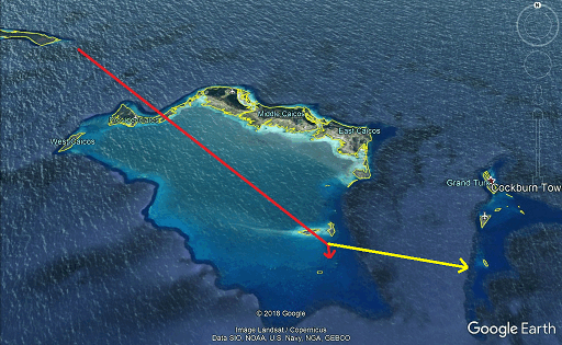
Supposedly, she went south a bit (from that island?) and then circled a round island. The 180 degrees south may be a typo or something misunderstood by the controller. At the end of the yellow arrow above is Big Sand Cay, but there is no little round island south of it. Yet if she did go south of Big Ambergris Cay, this would place her over a few scattered small islands— The Sea Cays and Bush Cay, one of which is round.
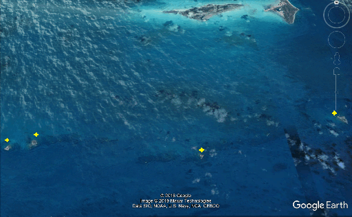
There is a circular island (see above) in the Seal Cays south of Big Ambergris Cay, but she couldn’t get to it on a 120 after having passed Big Ambergris unless her compass was really wonky.
Either way it is cut above, sending a plane on a 090 course eastward was fatal. There is nothing eastward of the Turks. There is nothing eastward from those small islands south of Big Ambergris Cay.
Cascio went east, this we know, at last thinking the Grand Turk controller was sending her to nearby South Caicos. She did not mysteriously break off from the safety of a populated island to head out into the deadly ocean. She was being assured she could make it. The investigators were surprised. She should have remained at the island and ditched.
There are no sectional or world aeronautical charts available that extend beyond 70 miles from the coast of Florida. USAF world and operational charts are available, but these are approximately three and a half by four feet in size, and two are required to cover the route followed by N8040L. These charts show non-directional radio beacons on Grand Turk Island, South Caicos and San Salvador Islands, but no radio frequencies are shown. Larger-scale ONC charts are also available, but they are no different in detail.
The true bearing from Georgetown to South Caicos measures 115 degrees, with slightly over two degrees west variation at Georgetown, increasing to well over four degrees at South Caicos. The distance from Georgetown to South Caicos measures 285 nautical miles.
The only Government-published charts of the area that show the radiobeacon frequencies are the low-altitude en-route instrument charts for the Caribbean and South America. These charts carry the low-frequency beacon frequencies as well as the magnetic courses and distances for amber airways to various points, but none cross Georgetown. These charts are available throughout the Miami area; however, no record of a purchase by the pilot was found.
The only navigational system available to the Cessna pilot was by nondirectional radiobeacons. The aircraft was equipped with a Narco ADF and two VOR receivers. Records of the pilot’s training revealed that she had not received instructions in the use of the ADF and was not considered qualified for this type of radio navigation. The male passenger, later identified, had no record of any aviation training or experience.
The flight-plan route of N8040L passed over an area dotted with islands, although much of the flight was over open water. Because of the pilot’s lack of training and experience, it is doubtful the operator would have permitted her to rent the aircraft had he known her intended destination.
When the pilot finally established radio contact with Grand Turk Island, she was already facing a desperate situation. With only 30 minutes of fuel remaining, she was completely lost, darkness was rapidly approaching and her low altitude made radio contact difficult. At 2006, the aircraft was circling a small, unidentified island, and the pilot was obviously reluctant to leave this last contact with land. At this time, the controller at Grand Turk began giving the pilot headings to fly, although the exact position of the flight remained unknown. The radio contacts show some confusion between the pilot and the controller regarding the headings given and the actual heading of the aircraft.
Four-Zero Lima was first advised to take a heading of 270 degrees. This course was never acknowledged; in fact, the pilot stated that she was continuing to circle the small island. Finally, a second heading of 090 degrees was given and repeated by the pilot. This vector was intended to return the aircraft to its point over the island; however, this may have actually been the first course taken to depart the island. Shortly after 2008, the pilot stated “...heading of 090. I have left the island.”
At 2012, the pilot was advised to take a heading of 120 degrees as her transmissions became stronger. The aircraft remained on this final course until fuel exhaustion about six minutes later.
Since VHF radio communications was possible with the aircraft flying as low as 650 feet, it is certain that N8040L was, in fact, very close to Grand Turk Air Force Base. At this point, even a minimal knowledge of ADF navigation would have led the pilot to a safe landing via the strong beacon located at the base. Since the pilot did not have this ability, and the controller did not think to instruct her in it, however quickly or informally, only one reasonable course of action remained to her: a forced landing on the island below her. This landing would probably have been successful if attempted while fuel still remained to allow the pilot a choice of landing sites. Instead, command of the aircraft was relinquished to the controller on the ground. This action alone was the most serious of all the many errors committed by the pilot, because the responsibility for the safety of the aircraft and its occupants remain with the pilot regardless of the circumstances.
When direction of the flight was turned over to the Grand Turk controller, the pilot joined him in the desperate hope that the airport could be found before the final minutes of fuel were consumed. Although it is difficult to understand why the controller issued specific headings without knowing the precise position of the aircraft, it is equally difficult to understand why the pilot turned away from the only known land and accepted a course that led her to a forced landing at night in the open sea.
Cascio clearly was not qualified to fly these outback routes because of her lack of ADF training. These airfields did not have homing beacons.
But why she got lost and why she disappeared are two different things. The Grand Turk tower controller should by no means have assured her she was close to South Caicos, nor given her headings when he didn’t know where she was.
Still, even with the assistance of Google Earth, as this article shows, it is not really possible to determine where exactly Carolyn Cascio and Richard Rosen were if following Cascio’s words exactly.
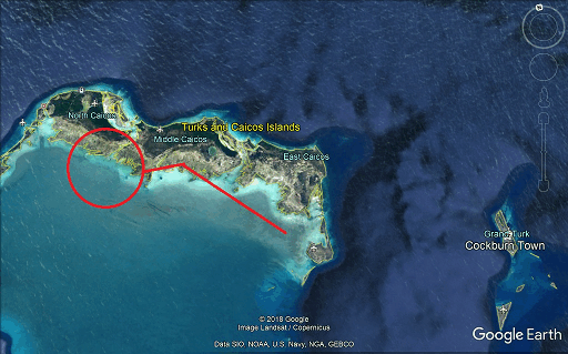
The above represents an attempt to understand what the Grand Turk Tower controller was thinking.
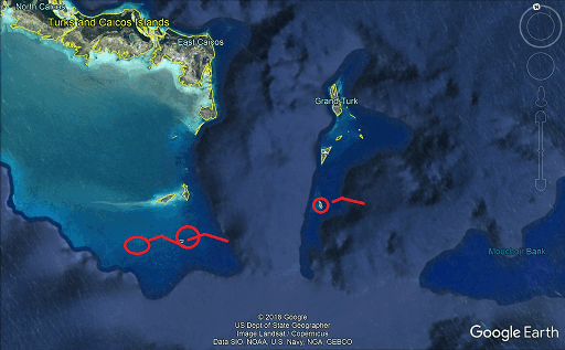
Above, my reckonings.
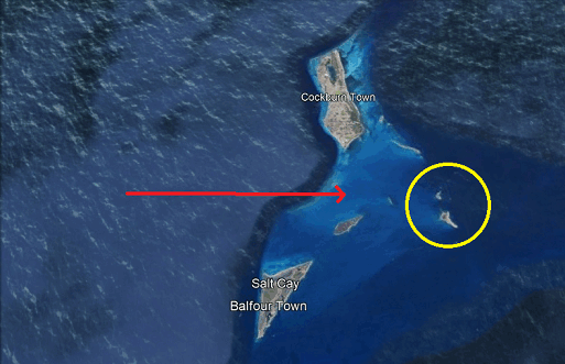
The origins of the legend, above. GTT operator’s original theory was that Cascio had passed between Grand Turk (elongated) and Salt Cay (diamond shape) and ended up circling one of these 2 small hinter islands. When he later learned (during the investigation) that she could not have been near North Caicos, he must have (guessing a bit, but it is a reasonable surmise) gone back to the original theory. Even at 650 or 1,000 feet circling an island here how could she not have seen the powerful lights of Grand Turk? She flew off to the east, to her doom. The legend was born. Is there any truth to it? Or am I right and she was further south?
One thing is true about the legend. She called out from the void. All radio controls and the three pilots could not get a fix on her. She vanished eastward into the night. . .but from where?
The investigators were right. She should have ignored the tower controller and ditched by that island, that island no one can identify to this day, some island of the lost, some island that might as well be in another dimension since it still escapes our reasoning today.
My personal thanks to librarian Phillipe Gagnon. He inspired me to finally present this case in detail. It wasn’t enough that I had the printed text and information. It’s a daunting task to type all this out. Phillipe, a dedicated researcher, had already transcribed the narrative and radio transcript of the accident report and sent it to me. At last, I realized, the case of Carolyn Cascio could finally be introduced in detail for the first time.
|


